 |
| Barranco de las Nieves, or maybe de las Laguentas, or maybe de la Mina. Go figure |
My legs!!! Three days later, they're still hurting. That's the first and the last thing that comes to my mind when I think about this hike. But surely there has to be something else to remember, right?
Back in February, Tamara did this walk (and got lost) on her own. This time, I was helping. We still got lost, but in a slightly (?) different place. I know, I know, let me start from the beginning.
 |
| Dry quaking grass. Everything's dry in fact. |
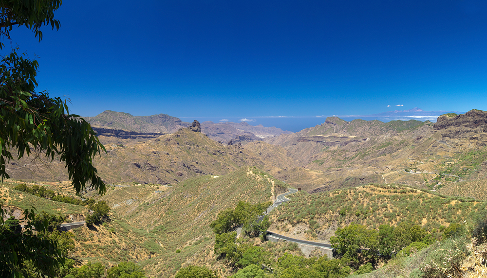 |
| Start of the walk. Full sun and clear view of Tenerife |
We didn't exactly get up early and arrived at Cruz de Tejeda already after 1 pm. I still have to get used to weather contrasts here. After the grey morning in Las Palmas (the sky was covered by panza de burro), this place met us with blazing sun, heat and a clear view of Tenerife. Also, no view of Las Palmas whatsoever.
 |
| Half-way up the initial ascent (compare to the winter version of the same view) |
Up, up, up we went. I took some more pictures of Roque Nublo (not featured here), to add to hundreds more, of more or less the same, in various stages of digital decay, before we entered the forest. Before starting the descent, we decided to check if there was a better view of — wait, what is that on the horizon? Fuerteventura or just some more clouds? So we walked a kilometre or so to the east along the road. Nope. The view was not any better.
 |
| Pine forest at the first diversion. |
Well then, we started to descend. In contrast to winter, this time the path was completely dry. You'd think that would make it easier to walk. Wrong. The dust made it as slippery (I am told) as it was when it was in its "mud" state. This is the first time I started to think that a trekking pole may be not such a useless accessory. Well, we didn't have any.
 |
| Some nice boulders there... Also, a "view" of the rest of the island under "el mar de nubes". |
 |
| Old man's beard (Usnea spp.) |
 |
| Sunflowers in Lanzarote, Valleseco |
Apart from that first diversion, our walk looks almost linear on the map (see below). But it wasn't. When we got to a ridge above Valleseco, the point after which Tamara remembered getting lost last time, we took the OTHER path. That is, where Tamara went up, we went down. And so we found ourselves descending into some barranco. The path featured many a hairpin turn, forks, a lot of brambles and no pointers of any kind. We weren't at all sure if we are on the right path. Still, it would be even more wrong (and uphill!) to turn back. On reaching the bottom of the barranco, we crossed a stream. There we noticed a sign "Teror" hanging on a tree. Hallelujah!
 |
| Fear not, somebody watches over us. |
We followed the arrow for a while, now walking uphill, until I consulted my not-so-smartphone and discovered that, instead of heading north-east, we were moving in the opposite direction. That's what happens when the sun is almost directly overhead.
Long story short, we found a properly signposted path after all, while blackberries and wild-ish plums (ciruela del país) provided subsistence. (Also, in a few weeks, the figs should be ready to eat!) It was there and then, out of the African sky blue, that my knees made themselves known. The last few hundred meters of descent I had to walk backwards, trying to confuse my phone even further.
 |
| Ciruelas del país, promptly harvested and brought home as a trophy. |
Once in Teror, we found a bar and had our well-deserved beer before catching a bus to Las Palmas. The entire walk took four and a half hours.
Route
Distance: 14.12 km
Up 268 m
Down 1189 m
Pictures of Gran Canaria on shutterstock - here
Text by Kirill, photos by Tamara


No comments:
Post a Comment