 |
| So far, this is probably my favorite kite ever. It was there all these years, I think. I even have it on the cover screen of my laptop. Looks alive, doesn’t it? Like a sandworm, except harmless and beautiful |
Showing posts with label fuerteventura. Show all posts
Showing posts with label fuerteventura. Show all posts
Tuesday, November 13, 2018
Fuerteventura, traditional post of November
Wednesday, December 20, 2017
Fuerteventura, November 2017 - Kite festival and some other things
 |
| The octopus keeps turning up every year. He is one of the biggest kites at the festival. |
Every year, in November,
I missed the year when we were living in Finland, but apart from that I always caught the festival, at least partially.
 |
| Sharks are beginning to fly in the morning |
Tuesday, January 26, 2016
Vamos a la playa, Oh — ohoh ohoh! Playa de Cofete, Oh — ohoh ohoh!
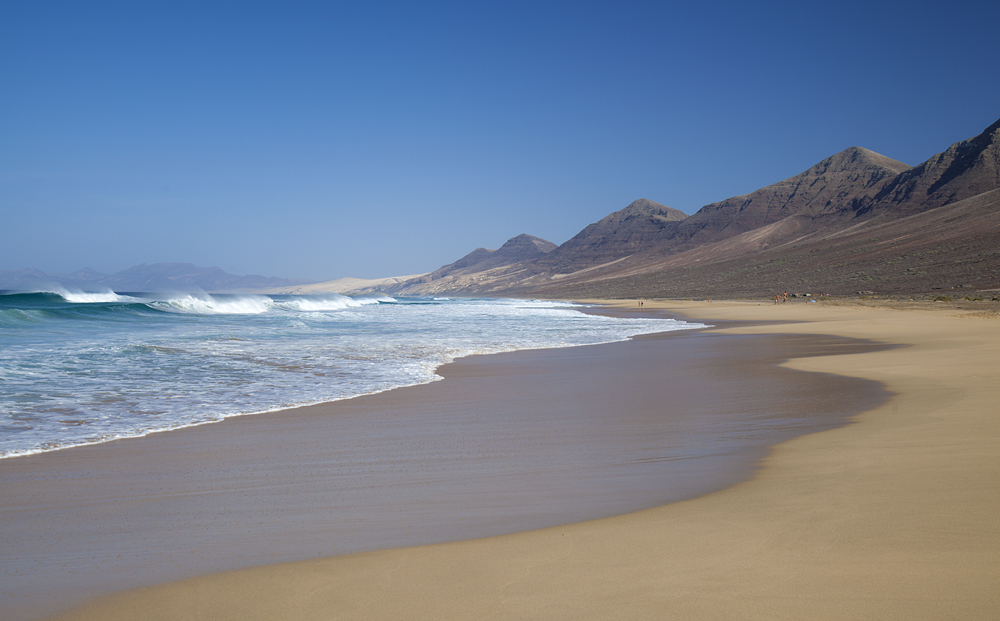 |
| Cofete! Finally :) |
This weekend, 23—24 January, we came to Fuerteventura yet again. We used an excellent Bintazo offer by Binter Canarias *. And we came with a very specific aim in mind — to get to Cofete, a difficult-to-access beach on the windward side of the island. I saw it a couple of times before, but never visited the beach. Kirill never even saw it from the ground level.
Getting there takes some research. The road is quite bad, as you will see later. Soon after you pass the port of Morro Jable, the surfaced road changes to a dirt track, very winding and bumpy. Normal cars can go on it, and will reach the beach eventually, but you are not supposed to drive rental cars on dirt tracks. No one will stop you, but if anything goes wrong, you will pay through the nose. You can walk, but that will be heavy going. I estimate the distance between the car park (where the dirt track starts) and the beach to be about 8 km. Plus you have to go by Cofete pass, which is at about 300 meters above the sea level, so each way will feature 300 meters of both up and down. And there is no shade. Biking is possible, but also strenuous and quite dangerous.
Now that you are sufficiently scared, let me give you a solution to this conundrum.
Tuesday, December 01, 2015
Fuerteventuuuuraaaa

Although I wasn’t tough enough to stay on Fuerteventura for more than two years, it keeps calling me back.
I went there in the beginning of November, to photograph the Kite Festival, to visit some familiar places, and to meet old friends. Pure nostalgia, it was.
Don’t really know what to write, apart from some short comments for the photos. Enjoy!
Thursday, February 13, 2014
Flamenco photoshoots with Anna Villacampa Gómez

At last, after almost a year of thinking about it, I am writing about two flamenco-themed photosessions that we had on Fuerteventura with Anna Villacampa Gómez, a beautiful lady and a great dancer. As usual, we procrastinated for an awfully long time before arranging the shoot — and the arrangement was finally made only because of our imminent departure.
One of the photoshoots was in the dunes of Corralejo, and the other in the malpais on the road to Tetir, by dead fig tree shaped by the prevailing winds. The second location was suggested by Anna, while we’ve been planning to do the dunes for two years. A piece of red gauze was bought to fly in the wind, Anna choose her own favourite dresses and off we went.
She proved to be a great model. Despite the heat on both days, she was happy to pose and move and dance. The minimalistic background of the dunes worked like a charm, and the dead tree, although making pictures a lot busier, always provided some parallels to the graceful movements of the dance. I enjoyed both days immensely, and so I hope did Anna.
Pictures in no particular order. Enjoy :)
Thursday, June 27, 2013
Barranco de las Penitas

In line with our moving plans, there are almost no place left on Fuerteventura where I really wanted to go and didn’t get yet.*
Last week we went for a walk in Barranco de las Penitas — one of the greenest places on the whole island. It’s a sort of continuation of the valley where the old capital of Fuerteventura, Betancuria, sits. The barranco (ravine) runs towards the west coast of the island, joining eventually with El Barranco de la Madre del Agua, to form even bigger Barranco del Ajuy, which flows into the ocean by (you’ve guessed it) Ajuy.
Thursday, June 13, 2013
Morro Jable — Gran Valle — Cofete Pass — Villa Winter
 |
| A view towards Villa Winter from Degollada de Cofete (Cofete Pass) |
Cofete is one of the places on Fuerteventura where I always wanted to go and somehow didn’t manage to do so. Even now I can only put a half-tick in that particular box (which is a bit nonsensical, same as the one-palmed clap). But I came close this time.
I have now so many people and organizations from Fuerteventura listed as contacts in Facebook that it brings me all sorts of useful info. On the page on Cabildo (sort of like the island’s council) I saw an announcement of the excursion to Cofete organized within a program called “Fuerteventura al Golpito”. They arrange excursions more or less every two weeks, provide a guide (or two, as it was in our case), and a free bus which picks people at Puerto del Rosario and Gran Tarajal. You have to phone and put your name on the list, and then they send you a message a couple of days in advance, stating the meeting place and time, plus in this case a change of route.
The original route was estimated to be two hours longer than the one that we eventually did, and I am jolly glad of the change too. It was hard going as it was, we were back in Morro Jable in six hours instead of the estimated four, and we didn’t stop for very long anywhere. Even the stop at Villa Winter was rather brief.
The Villa Winter itself was rather disappointing, I must say. I don’t know what I expected really, but the place has this aura of mystery about it (hidden rooms! secret passages! a submarine can come up right to the basement! etc.) so I didn’t expect goats, rubbish in the inner courtyard and peeling walls. Maybe, if the owners allowed us into the basement, as they sometimes do apparently, I would be more impressed, but they didn’t, so I wasn’t.
The route was beautiful if somewhat hard. Shame that we didn’t have time to come down to the water level, but that would probably have delayed us a lot more, and the bus driver was apparently getting really impatient as he was counting on the shorter time.
Saturday, April 20, 2013
El Barranco de los Enamorados — or so I think at least :)
 | |
| Face of the barranco. Chess Pieces. Moai of Fuerteventura. Take your pick |
I wanted to find this particular ravine, El Barranco de Los Enamorados (or de los Encantados), ever since I saw some amazing pictures of it in Facebook. It proved to be not that easy — my excellent KOMPASS map doesn’t have this name, and all the local maps I saw so far don’t have even the most basic stuff, let alone barrancos. I wanted to join one of the excursions that are organized by local walking groups — that didn’t happen somehow. I asked for the directions and got contradictory answers (it’s close to Lajares — no, actually, to La Oliva — no, it’s very close to the Playa de Esquinzo — it’s to the left — no, to the right — actually, just carry on straight...). I asked to point it out on a map; even that was a bit vague. So. I am inclined to think people talk about somewhat different places, but all of those places share one thing — amazing smooth water patterns on the sandstone.
Choosing the directions that pleased me by their simplicity (“just take the unused branch of Lajares roundabout and carry on straight, you can’t miss it”) I went there with a friend. We followed a huge barranco that starts close to Lajares roundabout; when we came to the place where it separated into three branches we started to walk the middle one. We soon met a small group of people, all looking local, and asked them for directions, just to make sure. The main guy took the words out of my mouth — “El Barranco de los Enamorados? No, you took a wrong turn, we are going that way, follow us and then I show you were to go”. (So much for “it’s straight, you can’t miss it”). We followed them to where they parked their 4x4; he told us that “from here it’s probably one more kilometer that way”. Off we went. Problem is, barrancos tend to branch off. That day we took a “wrong” branch — it was nice and had some interesting sandstone structures which were probably petrified plants — but we haven’t found what we were looking for.
So, we went again. This time we found all the stuff you can see on the pictures. I am still not that sure that we found “the” barranco, but I will give the route we followed, and point out at least one alternative I found. I can tell you without false modesty that my pictures are a lot better than what I saw before, but can’t tell if that is because we found a better place or it’s just because I haven’t seen other pictures that do the place justice.
Thursday, April 11, 2013
Montaña de la Arena
 |
| We didn’t have much luck with the sun during this excursion. One of a few small pools of light on the landscape |
Montaña de la Arena is a small dark mountain between Lajares and Villaverde/La Oliva. I passed it many times when doing a part of trans-Fuerteventura path GR 131. Once we tried to go up it with friends, but turned back when we discovered that the side of the mountain that we choose was one large scree. That was the side which looks at Lajares, northern face more of less.
When I saw the announcement of the excursion to the Montaña de la Arena on Facebook, I joined. I figured that maybe there is a good path up that I failed to spot myself.
Well, I was wrong. Where we went, there is no good path. There are bits when it looks sort of like one; but those are separated by stretches of pure picon, black volcanic gravel. You step up and slide down by the same amount, and you step up again, and you guessed the rest. It’s not an easy climb, and I don’t recommend to go where we went — southern face.
Sunday, March 31, 2013
Pico de Zarza

While Europe is getting an unhealthy share of snow and cold, it’s getting hot and summery here on Fuerteventura. So I figured it’s time to do this walk before it becomes impossible, or at least very, very uncomfortable.
Pico de Zarza is the highest point of Fuerteventura, just over 800 meters high (just now I found a figure of 807, but it seems to me that I saw some other heights somewhere). When the sky is clear you can see all of Fuerteventura, Gran Canaria and Teide on Tenerife from there. The sky wasn’t that clear when we went, so we didn’t see the other islands. Still, the views are spectacular and the walk well worth doing.
Above is the view along the wild Cofete beach (btw, the only remaining point of the island that I really want to visit and haven’t visited yet).
Wednesday, March 06, 2013
From La Pared to Sotavento de Jandia
 |
| The urge to climb and then jump off the sharp rock is irresistible to some |
Last Saturday we went for a long walk with my former Spanish class. The walk started around La Pared village on the west coast of Fuerteventura, ran along the shore for the goodish while, and then started to traverse the island. It ended up at main road FV-1, at the level of southern end of Playa de Sotavento de Jandia.
I liked the walk a lot, the coastal path is absolutely spectacular, but there are a few somewhat difficult points about it that I’d like to record.
First, logistically it’s not easy to organize on your own. It’s not circular, and if you want to go by car, you will have to go through a palaver of arranging at least one at the end of the walk, then ferrying people between the end and the start. We had it easy, as the center provided the bus that brought us to the start and picked us up at the end. I am not sure if the walk is doable by just public transport, but inclined to think that it isn’t.
Second point — most of the route runs along the sandstone ledge not much above the high water level, and under a tall wall of sandstone. There is no or very little mobile reception; so not a great idea to try the walk on your own even if you managed to somehow arrange the transport. Apart from our large group, we met very few people along the path.
Third point, linked to the previous — sandstone ledge runs out occasionally, or becomes quite steep. Nothing too bad, but — watch out and have somebody else watching out for you.
Apart from that, nothing much I can add. Enjoy the views :)
Sunday, February 03, 2013
Tindaya

I was looking in the direction of Tindaya for quite some time, figuring out how to get there without a car. It’s possible, but tricky, as there are just three buses per day that go past the village. You can start from further, at La Oliva, but that involves walking some nine kilometers to the mountain before going up, and that somehow didn’t seem so very attractive.
Apart from that, there was always a nagging question that nobody could quite answer — do you need a permission to ascend Tindaya, it being a protected area, sacred mountain and all that.
So I was really happy when I got a call from my former Spanish teacher saying that there will be a group excursion for Tindya, that we have enough cars and that he sorted out the group permission with ayuntamiento (district council) *.
Sunday, January 20, 2013
Montaña de Ecanfraga, take two

On Friday I had another go at Ecanfraga. This time I thought, “ok, I couldn’t go around it before, but I did go half way up. Now, I will try to go up”.
I almost succeeded, but only almost. My map doesn’t show the way up, so I have to choose how to go myself. The caldera of Ecanfraga has the usual horseshoe shape, maybe a little more angular than the others. I choose to go up by the side of the horseshoe that is closer to Villaverde. I came close, but the path disappeared completely about 30 meters from the top (that’s my estimate, and I am not very good at judging distances up). It was still possible to carry on up, the stones are solid and not slippery, but I was alone and chickened out somewhat.
Saturday, December 15, 2012
Montaña de Ecanfraga

I was going to walk around Montaña de Ecanfraga, a big mountain close to Villaverde, ever since my excellent map arrived. Map shows two routes, one that goes around Montaña de Ecanfraga only, starting and finishing in a different bits of Villaverde, and a longer one, which makes a loop around Montaña de Caima too. My intention was to try the shorter one.
I was somewhat disappointed this time, because I couldn’t match the map to Googlemaps. Where the paper map shows a route, aerial photography shows nothing much. And there might be a good reason for that, because there was no clear visible path soon after I’ve turned off a dirt track into the malpais. Maybe the idea is that you can’t go very wrong there, with two mountains on either side of you for the orientation, and you can just pretty much go as you please, I don’t know. I intend to give it another try some day, but this time I decided to go up the mountain instead. Amazingly, there was a double tyre track going up. The distance between the tyres made me think quadbike, but I am not sure. The track went on an incline where no right-minded person will drive any vehicle at all in my opinion, either up or down. Walking is fine though, not too scree-ey, although on a steepish side of course. I found about a million different paths going up and down the mountain; I think most of them are made by goats, not by humans.
I include the route I took below.
Tuesday, December 04, 2012
Ajuy to Arco del Jurado

Last week my friend was staying with us. He is a lot less nervous driver than I and together we managed to visit some places on Fuerteventura where I’ve never been before (and probably won’t go again, considering how steep and narrow some roads are).
This road that leads to this walk, I am happy to say, is not one of those. I did drive to Ajuy myself before, and it’s not too bad at all. But I was not even aware that there is this stone arch just a short walk away from the village.
Fortunately, recently I bought a large-scale map of Fuerteventura by Kompass. It has a lot more information on walks that I was ever able to find before. So when we made a vague plan to go “somewhere there, maybe Ajuy”, I had a look at the surrounding area and found “Naturdenkmal Arco del Jurado” (yes, the map is mostly in German). Quick search on Google produced some images that looked good, so off we went.
The walk is very easy, no ups and downs of any significance. If you find yourself climbing up or down, stop and look for alternative route, there surely will be one.
Saturday, November 24, 2012
El Cotillo and sunset fishing

Today, me and Yuri went to El Cotillo in the evening to catch a sunset. Corralejo looks to the east, and I am not an early riser normally, so there is a very little chance of catching either in the two “sun just above the horizon” moments. El Cotillo is perfect for sunsets.
The bus driver who took us there looked at the tripod and repeated several times that the last bus back is at eight, at eight, get it? Am I got? I found it rather sweet that he was so anxious for us not to miss the last bus. Somewhat intrusive perhaps, but that’s all cultural, your business is everybody’s business it seems.
Friday, November 16, 2012
Lajares to La Oliva

Essentially the same route as here, but this time I did the slightly longer version that ends up in La Oliva, following the trans-Fuerteventura footpath GR-131 in its Etapa 2 exactly. It was cooler today and I was alone (no complaining kids in tow), so it worked out nicely.
Another significant difference with the earlier walk was that now there is so much more green. It makes me happy to look at the green patches and the flowers. The flowers above and below are Chrysanthemum coronarium, garland chrysanthemum, and now there are groups of them here and there. I had to go down on my knees to shift the perspective and make this patch look bigger, but I do hope that eventually we will have more and I won’t need to do that. I might do it still, but it woud be nice not to have to.
You can see Montaña Colorada in the background of both of those pictures.
Thursday, November 15, 2012
Flowers finally :)

I was waiting and checking, waiting and checking, and the flowers finally appeared. It’s not what you may call a field of flowers, but you can see patches of those small white ones on the edge of the dunes, in that place I went to check on the greenery last time.
Of course, I didn’t know what they were. And once again, I was impressed by the power of Facebook. I sent a message here and received my answer the same day. I don’t know who maintains this FB page (author of the book, maybe), but whoever it is, thank you once again.
It’s Androcymbium psammophilum, a “vulnerable species” due to restricted habitat, only found on Fuerteventura and Lanzarote. The number of plants that appear each year differs greatly and depends on the amount of rainfall. I feel absurdly proud that I spotted them :)
References
http://www.floradecanarias.com/androcymbium_psammophilum.html
http://www.iucnredlist.org/details/162355/0
Sunday, November 04, 2012
Green is appearing

Today I decided to go and check out the dunes after the big rain of last week.
Now, the authorities (and I can’t even tell which ones, to be honest) in their eternal wisdom closed the dunes for pedestrian access about a month ago. That is, they erected, for want of a better word, some signs all around the edge of the natural park, about fifty meters apart from each other. Signs say that there is no access the the dunes. The same signs also say that you can’t light fires there and can’t pick up flowers or bother the wildlife. Last two bans seem a bit excessive, because if you obey the first one you won’t be able to do either of the followings two, but there you go. I guess to simply say “no access” appears too harsh or unfair or something.
There are two signs that are different from the others. They say that you can, in fact, enter the dunes (presumably in those two places), but you have to stay on the path. Problem is, there is no single definite path, at least no marked one, so once you are in, you can move with a crazy randomness of a happy butterfly.
You can probably tell that I don’t like those signs and the ban itself, can’t you?
Friday, November 02, 2012
Lajares to Villaverde

Subscribe to:
Posts (Atom)


