 |
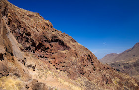
| Impressive cliffs of Tamadaba. |
 |
| Cuevas de Berbique |
Interurban bus company "Global" : https://www.guaguasglobal.com/
Las Palmas - Galdar : numbers 105 and 103 once every twenty minutes.
Galdar - Valle : number 102 (very infrequent!)
Puerto de las Nieves - Las Palmas : 103
If you don't want to catch the infrequent bus, you can do a different route, starting from Agaete, but it will be longer and with more ascent. But it is perfectly possible.
 |
| Dangerously invasive, but beautiful, crimson fountaingrass |
There was just five of us on the bus from Galdar to San Pedro and we all got off at the same stop, Lomo de San Pedro. I was going to get off one stop earlier, but the other passengers told me that no-no-no, it is the next one. One of them even offered to walk with me for a while to make sure I am on the right track.
We talked a little bit and I found out that although he was perfectly knowledgeable about paths and walks, at least about where they start, he has never been on any of the walks himself. The reason is that he has vertigo, to such extent that he can't even look up (!) let alone down, the steep cliffs surrounding his little village. Imagine, you live is a narrow alley and you never, ever, look up the sides. I can't.
Anyway, from the bus stop you have to cross the valley (and village) and start walking, always ascending. Crossing the valley sounds dramatic, but it is only couple hundred meters, and you are at the start of the walk to Tamadaba. First it goes along the slope, almost horizontally. In the route recording you can probably see that I did some wandering around at the very beginning - ignore it, just follow the path.
 |
| Digitial infrared conversion |
You can approach the caves if you wish (I didn't), but you have to find your own side path and ensure your own security. I think some effort was make to discourage people from approaching (such as metal railings along some parts of the path), but it is not actively forbidden.
 |
| Path marker. Don't know if it means anything. |
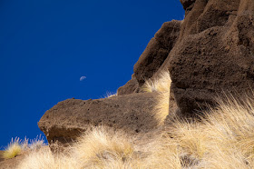
After the caves, the path goes through the out-of-this-world landscape of dark eroded rock. The omnipresent fountain grass makes it even more alien somehow.
 |
| Alien landscape. The orientation of the moon still surprises me sometimes. |
 |
| Dry fountaingrass. |
For a little while the path runs along one side of the valley almost horizontally. It was a weekday when I went and most of the way there was absolutely no one around, I only meet one couple walking down before I came to Era de Berbique.
 |
| Fred Olsen ferry is coming, Teide visible to the left |
 |
| Faneque, the tallest over-the-sea cliff of Europe |
On the photo above you can see the road Agaete - La Aldea de San Nicolas. It was always the most dramatic road of Gran Canaria, having tall cliffs on one side and near-vertical drop to the ocean on the other. Last year, they cut a tunnel through a massif closer to La Aldea, shortening the road way by about 20 minutes and making it a little safer, if somewhat less spectacular. Next stage, they are going to drill through Faneque.
I got a little extra bit of knowledge from doing this walk - now I know where I can see temporary waterfalls after the rains and how to get to them reasonably easy. They are just about 1 km into the walk. So... I'll be back when the rains start.
Elapsed time: 02:35:13
Distance: 7.85 km
↑ 435 m
↓ 585 m
Agaete , Tamadaba and Faneque on shutterstock
No comments:
Post a Comment