This post is mostly a reminder to myself to repeat (and improve on) the experience next year. Read on if you are interested in flowers though.
Some while back, when the spring was only just starting, I noticed that some of the companies that advertize for guided tours were offering "Ruta de Tajinaste azul" (Route of Blue *Something*, where "something" was a word I'd never seen before.)
A little while later, I went for a walk around Teror and noticed some tall blue flowers on the slopes - not many, and a little bit too far off the path to go and investigate. I got interested and then connected those two things together - people going to look at something blue, and these tall blue flowers, very visible amongst the vegetation that tends to yellow.
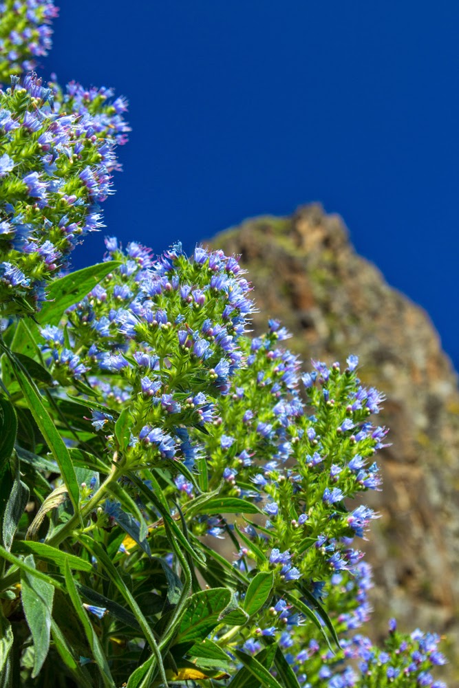
It turned out that Tajinaste azul de Gran Canaria is Echium callithyrsum, a plant endemic to the island. My Spanish is not good enough to dissect the word "Tajinaste" and figure out how it came to be, but the sound did associate nicely with the inflorescence of these plants, all bristly like a brush. Later I found out the the word is apparently of the guanche origin and is a derivative of tainast, which means "needle", so it all tied together nicely. The English name for at least some members of the genus Echium is "bugloss", something I am not sure how to interpret (lost bugs seem to be involved somehow).
I sort of left it at that, because the excursions I did try to join were completely booked and others were too expensive. And then later, quite by accident, I hit on a route that proved to lead to a perfect spot to see them, although I went too late for it to be the perfect time.
Come to think of it, maybe it wasn't a complete accident. The wikipedia page does mention the name Tenteniguada. It failed to register directly when I was looking up the plant. Maybe it lodged somewhere subconsciously though, because when I was deciding once again where to go for a walk, I settled on the Valsequillo area. The infrequent bus number 13 that links Telde and San Mateo has a complicated schedule - only a couple of buses complete the whole route, and most of them finish in Valsequillo, Tenteniguada or someplace called Casas del Rincon. I found from the long virtual walk through Googlemaps streetviews along the bus route that there are a couple of stands with maps and descriptions right next to the bus stop at Casas del Rincon. I figured it's a good place to start.
It was the right thing to do, but be warned - although the maps are placed by the bus stop the actual routes don't start there. You will see where the big volcanic plugs are though, and there is just one street that goes that direction, so follow it and you will soon find path markers and come to a place where there are two possibilities - to go to Presa de Cuevas Blancas or to Caldera Los Marteles.
I took the route to Cuevas Blancas, as it looked like it leaded between the two biggest, most obvious volcanic plugs - Roque Grande and Roque del Pino. Later I realized that I was following this route, but in reverse, i.e. I was going up where the suggested one goes down.
The path was going up pretty much all the time, gently at first and then quite steeply, and there were many places with loose stones and that special very fine dust, found in many places here, which is extremely slippery. When wet, it must be even worse, as it will all turn into mud, so it is one of very few routes where I would strongly suggest a walking stick in addition to the normal "good walking shoes" recommendation.
As I was going up and up, I saw more and more tajinaste bushes which had mostly finished flowering, with small blue flowers scattered on the ground below. After yet another bit of up and up I finally found some that were still in full bloom, at which point I realized that I'd better turn if I want to catch one of the rare buses back. But I was pleased no end anyway.
Now, my camera's data tell me I went there on the 7 May. I would hazard a guess that probably the best time to go would have been about three weeks before that, the middle of April maybe. The wikipedia page tells me that the largest and best known population is at the beginning of the other path - the one to Caldera de Los Marteles. So, next year, middle April, that's where I am going :)
Pictures of flora of Gran Canaria on shutterstock - here


No comments:
Post a Comment